Cornwall
2017-2020
Project Code: 011
SWEEP helped Cornwall and the Isles of Scilly deliver a range of environmental policies and strategies, and inform the location of £6.5 billion of development decisions under the Local Plan 2010-3020. This was achieved through innovative natural capital mapping, novel mapping of historic woodland to support Forest for Cornwall tree planting, and co-creative development of the ‘Lagas’ natural capital intelligence platform www.lagas.co.uk Hundreds of small businesses were also supported through the SWEEP-linked ERDF-funded Tevi project, boosting the region’s Circular Economy.
Project team

Why it matters
A healthy natural environment underpins the economy of Cornwall and the Isles of Scilly (CIOS). However, the region’s dependence on its natural systems, this is set to continue. For example, a further 52,500 new homes are anticipated in Cornwall by 2030 to meet local need.
Partners


Lagas has absolutely been designed to be accessible to a variety of users, whether that’s developers, their ecologists, potentially development managers, asset managers and people developing policy. We’ve been involved from the outset, working with SWEEP and others to ensure its functionality and presentation is ‘fit for purpose’ for end users. Its success has been in its co-design. We’re developing joint training sessions and super-users within Cornwall Council and other partner organisations who can champion its use.
Philippa Hoskin, Cornwall Council
What we did
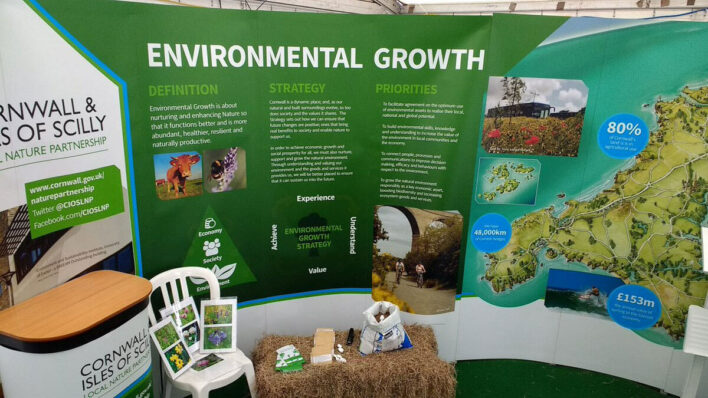
We developed a suite of landcover and ecosystem service provision maps, including a novel synthesis of existing and new landcover information for Cornwall, to support delivery of the ground-breaking Environmental Growth Strategy. Existing landcover resources were improved through innovative integration with remote sensing data.1
Work was instrumental in developing Cornwall Council and Cornwall AONB’s new environmental intelligence platform ‘Lagas’ www.lagas.co.uk, which adopted many of the SWEEP-developed natural capital maps, and was delivered as part of the Tevi project.
We developed a novel, automated method to digitise information about Cornish woodland and orchard coverage, from 1st Edition Ordnance Survey 1880 maps. Valuable in its own right, this work also provides ‘proof of concept’ for additional historic habitat layers to be extracted including, wetlands, heathland, rough pasture, built-up areas, and hedgerows/field boundaries.
Initial development of structured interview guide for small business engagements, which became spring-board for programme of ERDF-funded business assistance under the Tevi project and development of sustainable, Circular Economy-focused projects
Impacts & benefits
- Co-creative development of Cornwall’s capacity to access and use natural capital information spatially – The SWEEP mapping work brought together, for the first time, geospatial information on the relative value of natural assets and services across Cornwall. The maps and Lagas tool (which embeds them and makes them widely available) were developed in partnership with Cornwall Council and Cornwall Area of Natural Beauty to inform their ground-breaking and innovative environmental strategies and plans. Tailored training workshops and ongoing face-to-face support not only helped ensure these resources directly met partner organisation needs, but also became embedded for their use. Over 100 Cornwall Council and AONB staff were trained in the use of ‘Lagas’.
- Fostering wider understanding and debate on the use of natural capital spatial information – SWEEP contributed to an evolution in strategic decision making among Cornish partner organisations, in particular, their use of spatial information on environmental assets and opportunities. Outputs were presented and discussed at various workshops and inter-organisational meetings and resulted in:
- Environment Agency interest in opportunity mapping re: Working with Natural Processes for flood risk reduction
- Cornwall Wildlife Trust opportunity mapping method developments
- Interest from several other organisations including Dartmoor National Trust, Devon County Council, Devon and Somerset Wildlife Trusts.
- Cornwall Biodiversity Initiative Nature Recovery Network Mapping
- Defra ELMs Tests and Trials in Cornwall
- Activities, outputs and lessons learnt from the SWEEP work also informed the establishment of the Environmental Growth Evidence Group for Cornwall which seeks to ensure that evidence about the environment informs policy development and business activity.
- Informing regional environmental policies and strategies – 13 major regional policies and strategies informed – SWEEP-produced landcover and ecosystem service provision maps shaped a raft of Cornwall Council statutory development plans & strategies including:
- Environmental Growth Strategy (2020-2065) – adopted alongside Cornwall’s LNP, providing a long-term framework to conserve and grow nature.
- Biodiversity Net Gain (BNG) Planning Tool – helping to locate delivery of c.£6.5BN of 2010-2030 Local Plan housing need and biodiversity offsets.
- Cornwall Nature Recovery Network maps – providing a spatial prioritisation for nature and opportunities for habitat (re)creation.
- Climate Change Action Plan – adopted following Cornwall’s Climate Emergency declaration in 2019.
- Informing the flagship £30M project Forest for Cornwall – SWEEP’s innovative mapping of historic woodland cover helped to inform delivery of the Forest for Cornwall – Cornwall Council’s flagship natural capital solution project supporting it Climate Change Action Plan (2019). The Forest for Cornwall plans to create 8,000 hectares of canopy cover from individual trees in gardens, to whole woodlands, to urban trees, parks and hedges, covering approximately 2% of Cornwall’s land area. It will capture 38,000 tons of carbon dioxide a year and sequester (remove) upwards of 1% of Cornwall’s greenhouse gas emissions from the atmosphere.
- Supporting the Tevi business engagement programme – SWEEP’s early support of Tevi developing a semi-structured, interview guide for small business engagements, helped lay the foundations for its subsequent engagement with over 600 SMEs (since 2018) and direct support of 413 enterprises with a variety of tailored support. This included direct funding of 171 projects to help enterprises invest in the Circular Economy and environmental growth aspects of their business, and developing 25 national and five international partnerships. Tevi used Circular Economy and environmental growth strategies to help businesses improve the resilience of their processes, increase productivity, and play their part in growing Cornwall’s unique natural environment. It worked with businesses across Cornwall and the Isles of Scilly in all sectors, from agri-food and the marine sector to including clean energy, geo-resources, data and space, the visitor economy and financial services.
The Lagas maps have really helped Cornwall AONB identify opportunities and priority areas for nature restoration, as part of our Lizard AONB Test and Trial – a national pilot project for Defra… Its also helped inform and guide the direction we go in for nature recovery in our 5 yearly review of the Cornwall AONB Management Plan – a statutory document and material consideration in planning.
Emma Browning, Cornwall Area of Natural Beauty
Looking to the future
SWEEP mapping work is informing further Cornwall Council initiatives, including:
- The ambition to make the 104 farms owned by Cornwall Council (covering 4,525 hectares in total) “exemplars in low carbon and regenerative agriculture” (Cornwall’s Climate Change Action Plan; 6.25)
- Cornwall’s flood mitigation strategy, by helping to identify catchments and areas where natural flood mitigation schemes will deliver the greatest and most wide-ranging strategic benefit.
- Environmental opportunity mapping for Cornwall Wildlife Trust