
THaW
Tools for Tree, Hedgerow, and Woodland (THaW) Mapping.
THaW Mapping Toolbox Strategic Screening Tool and The THaW Change Detection Tool.
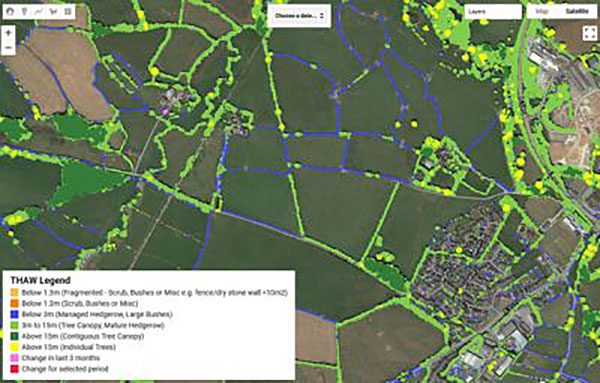
THaW Mapping Toolbox Strategic Screening Tool – This tool autonomously and rapidly generates high resolution, baseline THaW maps, across landscape extents, using 2m 2 LiDAR Data and bespoke data processing approaches.
The THaW Change Detection Tool – Drawing on THaW mapping data and spaceborne radar data, this tool adds an online platform which can autonomously detect changes to the mapped THaW habitats, through time. Using Sentinel I synthetic aperture radar (SAR) data, this tool enables remotely sensed canopy change detection to be mapped for any calendar quarter selected by the user, enabling close to real time tracking of canopy loss and woodland management.
If you are interested viewing or using either the THaW Mapping Dataset or the THaW Change Detection tool for non-commercial use, please contact Dr David Luscombe d.j.luscombe@exeter.ac.uk.